↓
 

Trussville Land Surveying

Your First Choice for Surveying in Trussville, AL.....

Trussville Land Surveying
  • Home
  • ALTA Survey
  • Civil Engineering
  • Drone LiDAR Mapping
  • Elevation Certificate
  • Land Surveying
  • Property Surveying
  • Topographic Survey | Topo Survey
  • Contact Us
  • Blog
Home 1 2 >>

Post navigation

← Older posts

Why Your Contractor Needs an As-Built Survey 

Trussville Land Surveying Posted on June 12, 2026 by TrussvilleSurveyorJune 1, 2026
Surveyor conducting an as-built survey at a newly completed commercial building

You’ve watched weeks or months of construction come together. The crew is packing up. The building looks exactly like the plans. So when your contractor mentions needing one more survey before everything wraps up, it’s natural to wonder why.

An as-built survey at the end of a project isn’t a formality. It’s a record of exactly what was built, where it sits, and how it measures up against what was approved. And it protects more than one person in the process.

What Changed Between the Plans and the Finished Project

Here’s something most property owners don’t think about: construction plans rarely survive contact with the real world without some changes.

A contractor shifts a building a few feet to avoid a buried utility line they didn’t know about. Drainage gets rerouted after the grading crew finds the slope runs the wrong way. A garage ends up slightly closer to the property line because the original stakeout had a small error that no one caught until the foundation was poured.

None of these changes are unusual. They happen on most projects, large and small. The problem is that when a project is done, the approved drawings no longer match the finished site. An as-built survey creates a new, accurate record of what actually exists.

Why Your Contractor Cares About This

Contractors deal with disputes. It’s part of the job. A property owner claims the driveway wasn’t built where it was supposed to be. A neighbor says the new fence crosses the property line. A building inspector questions whether the structure meets setback requirements.

Without an as-built survey, resolving these disputes comes down to memory, photos, and who has a better argument. With one, there’s a certified document that shows exactly where everything landed.

That document protects the contractor. If the building is where it was supposed to be, the survey says so. If a later dispute claims otherwise, the contractor has a signed and sealed record to stand on.

It also closes out the job cleanly. Many construction contracts require an as-built survey before the final payment is released. Lenders on construction projects often require it before converting to permanent financing. The survey isn’t an afterthought. It’s a condition of finishing.

What It Means for You as the Property Owner

The contractor isn’t the only one who benefits. Once the project is done and the crew is gone, you’re the one who owns the property and everything on it.

An as-built survey gives you a verified record of your finished improvements. If you sell the property in five years, a buyer or their lender may ask for documentation of what was built and when. If you want to add to the project later, an engineer or architect needs to know the exact location of what already exists. If a neighbor ever challenges where your fence or addition sits, you have a document that answers the question.

Think of it as the closing paperwork for your construction project. Just as a real estate closing produces a deed that records ownership, an as-built survey produces a record of what was built. Both matter long after the transaction is done.

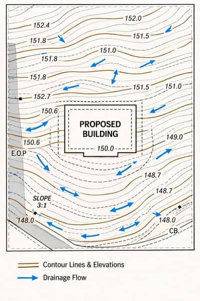
What the Survey Actually Documents

The surveyor visits the finished site and measures the real location and elevation of everything that was constructed. That typically includes:

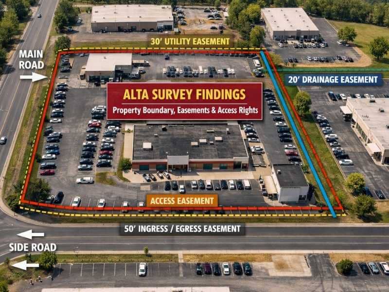
Building placement. The exact distance from the structure to each property line. This is how setback compliance gets confirmed. Zoning rules require buildings to sit a certain distance from lot lines, and the as-built survey verifies that the finished structure meets those requirements.

Finished floor elevation. For properties in or near flood zones, this measurement matters for insurance and permitting. The finished floor elevation on an as-built survey is the number used to verify flood zone compliance after construction.

Site improvements. Driveways, parking areas, walkways, fences, pools, retaining walls, and any other permanent features get located and documented.

Differences from the approved plans. If anything was built in a different location than what the permit drawings showed, the as-built survey captures that difference. Small deviations are common and often acceptable. Larger ones may need to be addressed before a certificate of occupancy is issued.

When Problems Show Up

Most of the time, an as-built survey confirms that everything is fine. But when it finds a problem, finding it now is far better than finding it later.

A structure built too close to a property line is a setback violation. If it’s caught before the certificate of occupancy is issued, there may be options: a variance, a minor adjustment, or an agreement with a neighbor. If it’s discovered years later by a future buyer’s title company, it becomes a cloud on the title that can complicate or kill a sale.

A finished floor elevation that doesn’t meet flood zone requirements can affect insurance coverage and may require corrective work to satisfy the permit. Catching it immediately after construction is much easier to deal with than discovering it when you’re trying to refinance.

The as-built survey isn’t looking for problems to create. It’s looking for problems so they can be resolved while the project is still fresh and the parties involved are still accessible.

How Long It Takes and What It Costs

Most residential as-built surveys are delivered within five to ten business days after the surveyor completes the field visit. Commercial projects with larger footprints or more complex site improvements take longer.

Cost depends on the size and scope of the project. A straightforward single-family home with no flood zone complications typically costs less than a larger commercial site with multiple structures and detailed documentation requirements.

The practical way to think about the cost is this: it’s a fraction of the total project budget, and it produces a document that has value for as long as you own the property.

Frequently Asked Questions

Can the contractor prepare the as-built survey themselves? 

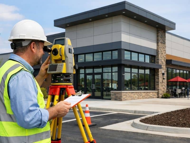
No. An as-built survey must be prepared and certified by a licensed land surveyor. A contractor, project manager, or architect cannot produce a document that carries the legal weight of a certified survey. The surveyor’s seal and signature are what make the document usable for permitting, title, and legal purposes.

Does every construction project need an as-built survey? 

Not every project requires one, but most new construction and substantial renovation projects do, especially when a building permit is involved. Requirements vary by jurisdiction. Some counties and cities require an as-built survey as a condition of issuing a certificate of occupancy. Others leave it to the lender or title company to require one. Check with your local building department early if you’re unsure.

What if the as-built survey shows the building is in the wrong spot? 

It depends on how far off it is and what the local rules say. Small deviations within acceptable tolerances are usually not a problem. A more significant deviation may require a variance from the local zoning board, an agreement with an affected neighbor, or in rare cases, physical changes to the structure or site. The sooner this is identified, the more options you have to resolve it.

Is an as-built survey the same as a record drawing? 

They are related but not the same thing. A record drawing (sometimes called red-line drawings) is typically prepared by the contractor or engineer and shows changes made during construction. An as-built survey is prepared by a licensed land surveyor through actual field measurements. The survey is the legally certified version. Both may exist on the same project, but they serve different purposes.

How long is an as-built survey valid? 

There is no fixed expiration date, but an as-built survey reflects the site as it existed at the time of the survey. If significant improvements or changes are made to the property after the survey is completed, the document no longer reflects current conditions. For permitting, title, or lending purposes, the party requesting the survey may specify a timeframe within which the survey must have been completed.

Posted in land surveying | Tagged land surveying

Before You Grade or Build Anything, Get a Topographic Survey First

Trussville Land Surveying Posted on June 10, 2026 by TrussvilleSurveyorJune 11, 2026
Surveyor conducting a topographic survey on a sloped site before grading and construction

Most construction problems start before anyone picks up a shovel. The slope was wrong. Water runs toward the building instead of away from it. The driveway needs twice as much fill as the contractor planned for. These aren’t random surprises. They’re things a good survey would have caught before the project started.

A topographic survey tells you what the land is actually doing before you spend money on a design or a permit.

What a Topographic Survey Tells You

Topographic survey showing contour lines, elevation data, drainage flow, and a proposed building location

A topographic survey measures the height of the land across a site. It shows high spots, low spots, slopes, and how water would naturally drain. It also maps physical features like trees, ditches, fences, existing buildings, and utility lines.

The end result is a drawing that lets an engineer or architect understand the land in three dimensions before any work begins.

This is not the same as a boundary survey, which shows where your property lines are. And it is not the same as an as-built survey, which records what was built after construction. A topographic survey is purely about what the ground looks like right now, and what that means for your project.

What Goes Wrong Without One

Skipping a topographic survey is one of the most common reasons construction budgets blow up. Here is what tends to happen.

Water ends up in the wrong place. A parking lot, building pad, or driveway that sends water toward a structure instead of away from it usually means the grading plan was based on guesswork. Fixing drainage after a concrete slab has been poured means cutting into finished work. That gets very expensive, very fast.

Dirt estimates are way off. Grading a site means moving dirt. How much dirt needs to move depends on the actual elevation of the land. Without accurate survey data, contractors guess. When the terrain turns out to be more complicated than expected, the estimates change and change orders follow.

Retaining walls appear out of nowhere. A slope that looks fine in person can require a full engineered retaining wall once a grading plan is actually drawn. If no one catches this until the design is done and permits have been applied for, the whole design may need to start over.

Stormwater plans get rejected. Most cities and counties require a stormwater plan as part of a building permit. That plan has to show how the site will handle rain runoff. Without solid elevation data, the plan won’t hold up. A rejected plan means delays, revisions, and lost time.

The foundation carries more risk. Engineers need elevation data to design a foundation that fits the site. A foundation built without it is based on assumptions. That is a risk no one wants.

Who Should Order One

Topographic surveys are not just for big commercial projects. If your project involves changing the ground level, adding a structure, or managing water runoff, you should have one.

Homeowners adding an addition or outbuilding. If the new structure sits on sloped ground or near a low spot, elevation data helps the designer get the placement right from the start.

Anyone installing a pool. Digging a pool on a sloped lot can uncover soil and drainage conditions you didn’t expect. Knowing the grade before the design is locked in avoids expensive changes after the hole is already dug.

Developers planning a subdivision or apartment project. Road layout, lot grading, utility placement, and stormwater design all depend on knowing how the land sits. Getting this data early reduces surprises at every step that follows.

Anyone building near water. If your project is near a creek, pond, or low-lying area, drainage gets complicated fast. A topographic survey shows exactly how water moves across the site during a rain event.

Contractors bidding on grading jobs. Accurate elevation data means accurate earthwork estimates. Bidding on grading without it means guessing, and a bad guess in either direction costs someone money.

When Should You Order It

Order the topographic survey before design work starts. By the time an architect or civil engineer begins drawing a site plan, they need to know what the terrain looks like. Finding out the grade doesn’t work after a design is half finished means redoing work that’s already been paid for.

For most projects, the order looks like this: topographic survey first, boundary survey at the same time or shortly after, then design, then permitting.

Not every project needs both. A simple fence only needs a boundary survey. A new home on a flat suburban lot with clean records may not need detailed topographic work. But if the project involves any change in grade, or if the permit requires a stormwater plan, the topographic survey comes first.

How Much Detail Do You Need

Not all topographic surveys capture the same level of detail. A small residential lot may only need elevation readings at a handful of key points. A large development site needs a dense grid of measurements that can produce contour lines at one-foot or two-foot intervals.

The right level of detail depends on what the data will be used for. Before ordering, ask the engineer or architect who will be working with the survey what they need. They will typically spell out the contour interval, the accuracy required, and which features need to be included. Getting those specs to the surveyor before the job starts means you get data that works for permits and design, instead of data that has to be redone.

Frequently Asked Questions

Does a topographic survey include property lines? 

Not by default. A topographic survey focuses on elevation and physical features. Property lines can be added if a boundary survey is done at the same time, but they are two separate products. If you need both in one drawing, ask the surveyor upfront. Many firms offer them as a combined service, and a single sheet with all the information is easier for designers to work from.

Can you use free government elevation data instead? 

Public datasets from government agencies are fine for early planning and rough screening. But they are often lower resolution and may be several years old. For permit applications, engineering work, and construction, most local governments require survey-grade data signed and sealed by a licensed professional. Free data is a starting point, not a replacement.

How long does a topographic survey take? 

A typical residential lot takes three to five business days. Larger or more complex sites take longer. If you are combining a topographic and boundary survey, the timeline covers both. Sharing any existing records, plat maps, or prior surveys with the surveyor at the start helps move things along.

What is the difference between a topographic survey and a grading plan? 

A topographic survey records what the ground looks like today. A grading plan is a design that shows how the ground will be changed during construction. The grading plan is created by a civil engineer using the topographic survey as a starting point. The surveyor produces one, the engineer produces the other, and neither does their job well without the other.

Do I need a topographic survey to pull a building permit? 

It depends on your city or county and the size of the project. Many permit offices require a survey or site plan that shows existing grades for new construction, additions, or any project with grading work. Check with your local permit office early so you know what’s required before you lock in your timeline.

Posted in land surveying | Tagged topographic survey

What Is an ALTA Survey and Why Does Your Lender Keep Asking for One?

Trussville Land Surveying Posted on June 8, 2026 by TrussvilleSurveyorJune 1, 2026
Aerial view of a commercial property showing ALTA survey findings, including boundary lines, easements, and access rights

You’re a few weeks into a commercial real estate transaction and your lender sends over a checklist. Near the top is a requirement you may not have seen before: an ALTA survey. If you’ve bought residential property before, this probably isn’t something you’ve dealt with. 

What an ALTA Survey Actually Is

An ALTA survey is a property survey that follows a joint national standard set by the American Land Title Association and the National Society of Professional Surveyors. The abbreviation ALTA/NSPS refers to both organizations, though most people shorten it to ALTA.

The standard exists for one core reason: lenders, title insurers, and investors need a consistent, reliable picture of a commercial property regardless of where it’s located. A boundary survey prepared in one state may look very different from one prepared in another. An ALTA survey looks the same everywhere because it has to meet the same requirements nationwide.

Why Lenders Require It

When a lender finances a commercial property, they are taking on significant risk. If the borrower defaults, the lender may end up owning the property. They need to know exactly what they’re getting.

An ALTA survey gives a lender confidence on several specific questions that a standard boundary survey simply does not answer.

Does the property have legal access to a public road? A commercial building with no legally established access to a street has a serious problem. The ALTA survey confirms how access is established and whether it depends on easements that could be challenged or lost.

Are there encroachments that could create legal liability? If a neighboring building, fence, or parking lot crosses onto the property being financed, that’s a title issue. The lender needs to know before the loan closes, not after.

Do recorded easements affect how the property can be used? A utility corridor running through the middle of a parcel can limit where a buyer can build or expand. An overhead power line easement may restrict building height. These restrictions directly affect the property’s value as collateral.

Does anything on the ground conflict with what the public records say? Sometimes a property looks fine on paper but has real-world conditions that the deed and title search don’t capture. The ALTA survey is a physical check on that.

Why the Title Company Needs It Too

A title insurer’s job is to guarantee that the buyer’s ownership of the property is free from undisclosed claims or defects. To do that, the title company needs to know what physical conditions exist on the property that might affect that guarantee.

Without a current ALTA survey, title policies typically include a broad “survey exception,” which is a clause that excludes from coverage anything a survey would have revealed. This exception protects the title insurer but leaves the buyer and lender exposed to physical and legal problems the policy won’t cover.

When a satisfactory ALTA survey is provided, the title company can remove the survey exception. That’s a meaningful upgrade in protection for both the buyer and the lender. It means the title policy will cover things like encroachments or boundary issues that would otherwise fall outside the policy.

This is one of the main reasons lenders specifically ask for an ALTA survey rather than accepting any survey. It’s not just about measuring the land. It’s about making the title insurance policy as complete as possible.

What the Survey Reveals That Can Affect a Deal

Most ALTA surveys come back without major surprises. But when they do reveal a problem, it is almost always something that would have become a serious and expensive issue after closing.

Common findings that affect deals include:

Encroachments. A neighboring structure, fence, or paved area crossing the property line. Depending on how long the encroachment has existed, it may require a legal agreement with the neighbor, a boundary adjustment, or in some cases creates grounds to delay or renegotiate the deal.

Easement conflicts. A building or improvement sitting within a recorded utility or drainage easement. The entity that holds the easement may have the legal right to require removal of anything built within it.

Access problems. A property that appears to have street frontage but technically relies on an unrecorded or informal access arrangement that isn’t legally protected.

Gap or overlap with adjacent parcels. A small strip of land between two deeded parcels that belongs to neither, or a spot where two deeds claim the same ground. These gaps and overlaps can complicate ownership and title insurance.

None of these are hypothetical edge cases. They come up regularly on properties that have changed hands multiple times, been subdivided over the years, or sit in older commercial corridors where improvements have grown without formal surveys keeping pace.

How Long It Takes and What Affects the Timeline

Most ALTA surveys for commercial properties take two to four weeks from the time the surveyor receives the title commitment and any prior survey documents. Larger properties, properties with complex easement histories, or projects that require specific optional items take longer.

The timeline also depends on how quickly the parties involved provide what the surveyor needs. A title commitment that takes two weeks to arrive delays the survey by the same amount. Getting all required documents to the surveyor as early as possible in the transaction is the most reliable way to avoid delays.

Posted in alta survey | Tagged alta survey

Post navigation

← Older posts
Get Quote Button
© Copyright Tucker Engineering, LLC
TrussvilleLandSurveying.com
Trussville, Alabama
Phone: (205) 208-1303

Web Development and SEO by:
N2Biz.co


Privacy Policy | Terms of Use

&nbsp Privacy Policy
↑